
Fighting in Kursk region: map of "Gray Zones"
The military operation in the border region of Kursk continues for the fourth day. The Russian side claims that fighting is allegedly "already underway 30 km from the Kursk Nuclear Power Plant" and 15 kilometers from another regional center - Lgov. Meanwhile, Ukrainian analysts have for the first time marked "gray" and "liberated" zones on the map of military operations.
What is happening in the Kursk region on the fourth day of fighting, maps and possible options for the actions of the Russian troops
According to morning calculations by the Russian media resource "Important Stories", the combat zone has already stretched over 800 square kilometers, and "under the fire control of the Ukrainian Armed Forces" is allegedly up to 450 square kilometers. Russian media claim that Ukrainian forces have penetrated approximately 30 kilometers into Russia and "occupied" or "are storming" 22 settlements, including two regional centers: Korenevo and Sudzha.
The situation is also "alarming" for Russians in relation to another regional center - the city of Lgov, from which locals have already begun to leave en masse. Russian Telegram channels write that allegedly Ukrainian servicemen can "go not only to Kursk", but also to the Kursk Nuclear Power Plant, located in the city of Kurchatov. It is noteworthy that from this settlement to the nearest battlefield there are about 50 kilometers left, although the "Z-channels" write about 30 km. In addition, some "Russian military correspondents" write about the battles for Rylsk, which is also a regional center.
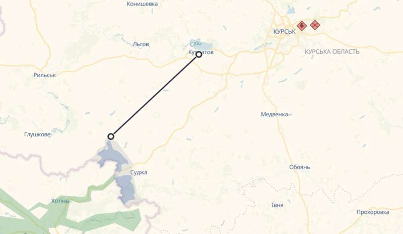
Photo: Fighting in Kursk region is getting closer to the local nuclear power plant in Kurchatove (screenshot deepstatemap)
What’s happening in Kursk region: analytics, battle maps
What is happening in the Kursk region: analytics, battle maps
For the first time since the beginning of the so-called "breakthrough", the Ukrainian analytical resource DeepState has shown a map of the battles in the Kursk region. Experts have marked the settlements that are not controlled by Russia in the region (this is an update for 6 August).
"Updates will be delayed. Some information may ultimately differ from the testimony of direct participants in the events," DeepState explained.
According to analysts, the Ukrainian Defence Forces "liberated Sverdlikovo, Daryino and Oleshnya".
"The Defence Forces struck near Sverdlikovo and Oleshnya. The first village was taken as a result of a battle, and the second without a fight or with minimal effort," the statement said.
According to experts, about two platoons of the enemy were surrounded at the Sudzha checkpoint. The village of Hornal was also surrounded.
"Advance groups have reached Honcharivka and the outskirts of Sudzha. Fighting in the area of Zelenyi Shlyakh, intensity is unknown. In Mykolaiv-Daryino, the enemy’s stronghold managed to hold off the first attack, but not for long," DeepState added.
In total, the area of the "liberated" territory in the two areas is 72.74 square kilometres and 70.25 square kilometres respectively. The "grey" zone in the Kursk region covers an area of 110.71 sq km.
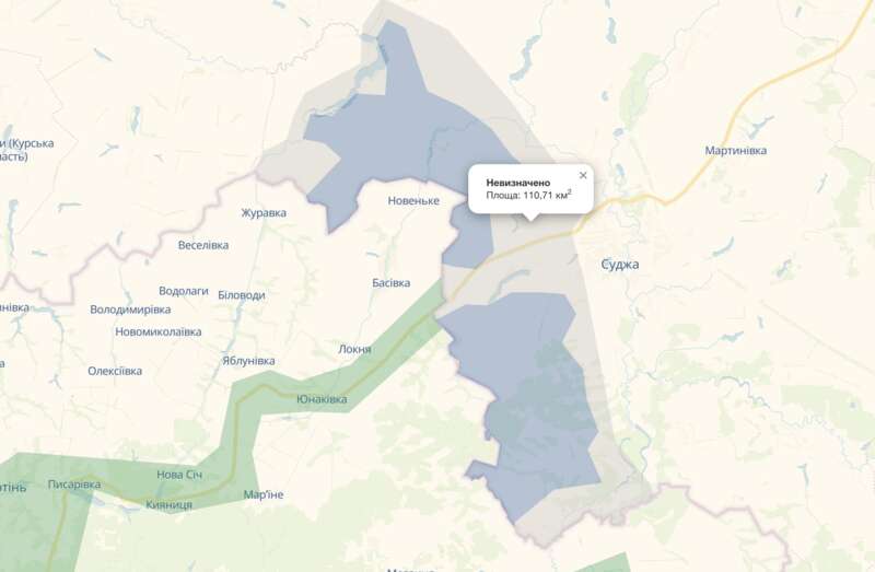
Photo: DeepState for the first time showed on the map the "liberated" territories and the "gray" zone in the Kursk region on the first day of the operation (screenshot deepstatemap)
The American Institute for the Study of War (ISW) writes about the presence of Ukrainian troops in Russian areas located 35 kilometers from the internationally recognized border with the Sumy region of Ukraine.
"However, Ukrainian forces certainly do not control all the territory within the maximum Russian statements about the advance of Ukrainian troops in the Kursk region," ISW notes.
Based on geolocated footage and Russian statements, analysts name the directions in which Ukrainian troops could have likely advanced:
- Sudzha. Some "Russian military correspondents" complain that the city has already been "captured", others say that the Russians do not control only part of the settlement.
- Milutino and Kromskiye Byki (35 kilometers from the border). It is noteworthy that these villages are already part of the Lgovskiy district of the Kursk region. These villages are marked on the ISW map as the highest point where the Ukrainian Armed Forces could advance.
- Russkoe Porechnoye (north of Sudzha) . Ukrainian forces have probably advanced in the direction of the village. Meanwhile, "Russian military correspondents" write that Ukrainian troops are advancing further - along highway 38K-024 near Anastasyevka.
- Goncharovka and Zaoleshenko. Ukrainian troops are probably operating in the area of the first settlement and north of the second. Although some Russian bloggers complain about the "capture" of Goncharovka.
- Novoivanivka (10 km from the border). Geolocation photo shows that Ukrainian forces are operating in this settlement, although the Russians are again talking about "capture" together with Bogdanivka (northwest of Sudzha).
ISW also cites a number of other Russian statements about the alleged movement of Ukrainian forces. They say that Ukrainian forces have also advanced to Malaya Loknya and the vicinity of the village of Cherkasskoye Porechnoye, as well as in the area of Kruglenky, Martynovka, Bolshoye Soldatskoye and near Mirny. This is the Sudzhansky district.
Russian war correspondents also wrote about an attack in the area of the village of Snagost and near Olgivka. These settlements are part of the Korenevsky district.
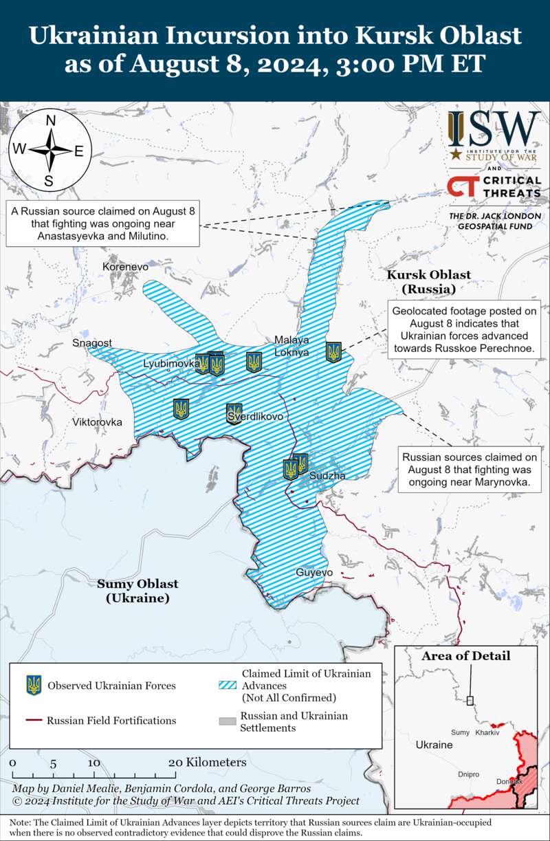
Photo: The ISW map shows the probable advance of the Ukrainian Armed Forces up to Milutino in the Lgov district (understandingwar.org)
Although the Russian publication "Agency", which positions itself as opposition to the government, claims that Lgov is 10 km from the nearest point of fighting.
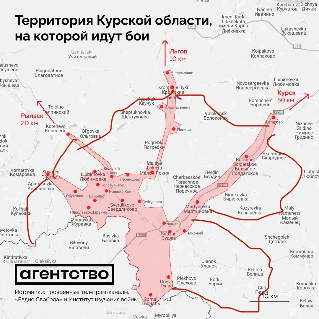
Photo: map of battles from the Agency publication (agents.media)
How Russia might act: Four possible scenarios from ISW
According to international analysts, the Russian military command has a number of possible options to respond to the cross-border operation in the Kursk region. ISW names four of the possible ones:
- First, the Russian Federation may decide to use its existing conscripts, Federal Security Service (FSB) border guards, the Russian National Guard, and other irregular forces already deployed in the international border area to push back Ukrainian troops and defend against a Ukrainian operation in the Kursk region.
- Second. Make a decision on the use of the existing Northern Group of Forces deployed along the Russian-Ukrainian border.
- Third, redeploy operational reserves accumulated for the planned offensive efforts for the summer of 2024 and relatively better-supplied and more combat-ready forward units to the Kursk region from other regions of the theater of military operations.
- Fourth, Russia may seek to maintain the forces it has allocated to the Kursk region, but could redeploy significant numbers of aircraft and strike units to the area in an attempt to improve its ability to retake the territory.
The US-based Institute for the Study of War (ISW) writes about the presence of Ukrainian troops in Russian areas located 35 kilometres from the internationally recognised border with Ukraine’s Sumy region.
"However, Ukrainian forces certainly do not control the entire area within Russia’s maximum claims of Ukrainian troop advances in the Kursk region," the ISW notes.
Based on geo-located footage and Russian statements, analysts name the areas where Ukrainian troops could have advanced:
Suja. Some "rosvoyenkory" complain that the town has already been "captured", while others say that the Russians do not control only part of the settlement. Milutino and Kromski Byky (35 kilometres from the border). It is noteworthy that these villages are already part of the Lgovsky district of Kursk region. These villages are marked on the ISW map as the highest point where the UAF could have advanced. Ruske Porichne (north of Sudzha). Ukrainian forces are likely to have advanced towards the village. Meanwhile, "Rosvoyenkory" writes that Ukrainian troops are advancing further along the 38K-024 road near Anastasievka, Goncharivka and Zaoleshenka. Presumably, Ukrainian troops are operating in the vicinity of the former and to the north of the latter. Although some Russian bloggers complain about the "capture" of Honcharivka. Novoivanivka (10 km from the border). A geolocation photo shows that Ukrainian forces are operating in this settlement, although Russians again claim "seizures" along with Bohdanivka (northwest of Sudzha). ISW also cites a number of other Russian statements about the alleged movement of Ukrainian forces. They say that Ukrainian forces have also advanced to Mala Lokna and the outskirts of the village of Cherkaske Porichne, as well as in the area of Kruglenke, Martynivka, Velykyi Soldatske and near Myrne. We are talking about the Suzhansky district.
Russian "military commanders" also wrote about an attack near the village of Snahost and near Olgivka. These settlements are part of Korenivka district.